South Coast NSW History Story
BATEMANS BAY
Traditional owners of the country now known as Batemans Bay and district, identify as the Walbunja tribe of the Yuin nation, which extends from Sydney to the Victorian border. So, “Wallawani” (a form of welcome in the local Dhurga language) to open this brief introduction to the rich cultural history of the area.
For thousands of years prior to European settlement, the Walbunja lived on country, travelling for resource exchange and social gatherings. Before 1788, the Yuin population in the area from Cape Howe to the Shoalhaven River and inland to the Great Dividing Range is estimated to have been about 11,000.
James Cook’s 'Endeavour' sailed swiftly up the coast in 1770, Cook’s journal noting fires along the coast as he passed. Cook sounded depths and marked key features to assist later navigation. Among them was a bay which he thought might make a harbour. In naming it Bateman, he honoured Nathaniel Bateman, a naval officer with whom he had served when surveying the coastline of the St Lawrence River.
After sighting the Endeavour, “Gurung-gubba – a great white pelican on the ocean”, 27 years passed before the Walbunja’s first physical experience with Europeans. A party of 17 survivors from the wreck of the Sydney Cove were walking the 700 kilometres from Ninety Mile Beach, in current-day Victoria, with the aim of reaching Sydney. The whole party made it to the Moruya area because they were often fed, ferried across rivers, occasionally ushered into camps overnight, and shown the way north by Aboriginal men who sometimes walked with them.
In the Moruya-Batemans Bay area, we don’t know how or why, but nine of the party perished and another five were lost as they made their way up along the Illawarra coast. Eventually just three men reached Sydney. (This story is told in Mark McKenna’s excellent book ‘From the Edge’, MUP, 2012 and in Recollections 47.)
In April 1808 a small vessel, the 'Fly', was driven into Batemans Bay by bad weather. Five sailors went on shore to replenish their water supplies, were met by a party of local Aboriginals, and conflict resulted. Three of the crew were killed.
In 1821 a ship carrying cedar cutters took storm shelter in the Bay. Local Aboriginals reportedly met the intruders aggressively, killing one man and injuring another and forcing the boat to head back to sea.
On the Governor’s instruction, Lt Robert Johnston sailed down the coast that year to assess Cook’s earlier named landmarks, and to investigate what happened to the cedar getters. Finding a navigable river must have been a pleasant surprise! Johnston stayed in the area for several days, anchored in the lee of the little island he named Snapper after his vessel.
In his journal, he wrote, “On my way up (the river), I saw several Native fires near the banks. At one place I landed, taking with me the two Natives who accompanied me from Sydney, upon which we were met by a tribe of them, who showed no symptoms of hostility towards us, but entered freely into conversation; and, through my interpreters, I learnt the particulars of the melancholy loss of Mr Stewart and his boat’s crew.” (He also dryly noted signs of axes and other metal objects around the huts.)
Explorers of the day claimed geographical ‘naming rights.’ As the first European to explore the river, Johnston named it the Clyde (its Dhurga name was Bhundoo), referencing his family estates around the Clyde River in Scotland.
Early the following year Johnston returned with merchants and explorers Alexander Berry and Hamilton Hume who were seeking opportunities for land development. Berry eventually took up land grants further north. The town of Berry is now located in his former Coolangatta estate.
In 1827 and 1828 government surveyors Robert Hoddle and Thomas Florance surveyed the area in anticipation of the southern boundary of the Limits of Location (the area from Sydney that could be legally settled) being extended south from the Clyde River to the northern bank of the Moruya River. At the entrance to the bay, Hoddle named two of Batemans Bay’s islands, Tollgate and Tollhouse (now known collectively as the Tollgates).
Hoddle’s opinion of the prospects for the area was bleak: “It is very barren. At least nine tenths of it will be suitable for no purpose whatsoever.” Here we might note Surveyor-General Sir Thomas Mitchell’s view of Hoddle: “…a man who can scarcely spell … this man can only be employed as he has always been, at the chain'. Literally, hauling a physical chain was the means by which land was surveyed.
In October 1826 John Harper, a member of the Wesleyan Missionary Society, travelled down the south coast in search of a suitable location to establish a ‘Mission to the Aborigines’. He put in at Bateman’s Bay and remained there for two weeks. He recorded his first impressions in his Journal, noting, ‘They are very kind to their women and children; the blankets which I gave to the men they gave to their wives and children...’. The Missionary Society subsequently applied to Governor Darling for a land grant. It was refused, Governor Darling stating “I have...lately declined authorizing the Wesleyan Missionary Society to select land, which they had applied for along the Coast of Bateman’s Bay, considering it would have been prejudicial to the interests of the Settlers”.
Settlement of Batemans Bay began in the 1830s, with timber cutters and fishermen active in the area. With European settlement expanding from Sydney as far south as Braidwood, it was inevitable that the two conflicting economic systems - those of European pastoralists and those of the Aboriginal hunter-gatherers - would collide, with resource competition becoming the focus of conflict. Within the Eurobodalla, however, there are few records of violent conflict, and most of the hostility that did occur was in the first decade of European intrusion in the area.
It was the gold mining rush of the 1850s that led to the establishment of regular shipping to and from the south coast. After amalgamations, the Illawarra Steam Navigation Company established itself as the primary carrier servicing townships from Nowra to the Victorian border. Nelligen, upstream of the current Batemans Bay township, became an important stop for hopefuls heading to the rich Araluen goldfields.
For over a century the Illawarra Steam Navigation Company was to contribute significantly to the economic growth of the district.
Batemans Bay township was surveyed in April 1859 and a postal service to the town was established the same year. Descendants of original land title owners still live in the district today.
Around 1860 a ship building industry was founded by local entrepreneur and businessman Francis Guy. Small oyster farming enterprises were also established along the Clyde River – and this is now the oldest established industry that continues from pioneering days. The district's first timber mill was opened in 1868 producing finished timber in such large quantities that steamers called to the town twice a week to transport its output to Sydney.
By 1869 the population of the town had reached 60 people, enough for a provisional school to operate. A public school replaced it in 1872, and the building with its adjoining schoolmaster’s cottage are two of the very few remaining historic buildings in the Bay.
Working relationships were formed from the earliest days with local Aboriginal employed in sheep washing, hoeing, harvesting maize and potatoes, cutting wood and stripping wattle bark. Several became servants. There are many documented examples of Aboriginals assisting newcomers throughout the early years of early European settlement. It seems they helped as a simple act of kindness or as part of an economic exchange. They provided information on the landscape, guided people to the area and to good locations for grazing stock or gathering timber.
The 'Town and Country Journal' in 1883 claimed the timber trade was almost the sole industry in the Batemans Bay and Clyde River district with 13 mills in operation and 3 being built. The ‘red gold’ of cedar did not grow past Ulladulla, but hardwoods were apparently in limitless supply as the town responded to a boom demand for railway sleepers.
The State Government’s establishment of a Board for the Protection of Aborigines in 1883, with its policy of encouraging Aboriginal people to live in separate reserves away from towns and cities, resulted in dramatic changes to the lifestyles of Aboriginals and their relations with European society. In the Eurobodalla, Aboriginal reserves were created at Wagonga, Narooma, Moruya, Terouga Lake, two at Tuross Lake, Yarboro, Turlinjah, Moruya Heads, Tomago River, Wallaga Lake, Currowan, Snake Island and Merriman Island in Wallaga Lake, and Narooma. Some of these were created to house specific families, many seem to have never or were rarely occupied by Aboriginals, and over time most of the reserves were revoked.
The Bateman’s Bay Reserve has a particularly interesting history and sadly illustrates how opposition from Europeans could result in Aboriginal children’s exclusion from their local government school.
Nine acres on the outskirts of Batemans Bay township had been set aside as an Aboriginal Reserve in 1902. By 1918 the town was expanding and the Batemans Bay Progress Association informed the Aboriginal Protection Board that the Reserve stood in the way of white residential development. In 1922 the Board agreed to encourage the residents of the reserve to move to a new reserve several miles out of town. Those families refused to move because they had already erected homes on the Reserve and because it was easy for their children to walk to the local primary school.
In 1924, further pressure from the white community led to the Aboriginal Protection Board agreeing to the revocation of the Reserve. Again, its residents refused to move.
The white community responded through the school’s Parents and Citizens Association. It voted to segregate the school, which effectively meant that 15 to 20 Aboriginal children would be given no education at all. Under the threat of segregation, Indigenous grandmother Jane Duren wrote to King Edward VII arguing, as subjects of the Crown, their children were entitled to receive State provided education.
Backed by some white supporters, they mounted a ‘sustained and well-coordinated campaign to have the segregation rescinded’…and two years later – after an assurance was given to white parents that an influx of Aboriginal children from other areas would not occur - segregation ceased.
The local Aboriginal community won this battle but eventually, some time before 1932 (and possibly as early as 1927), the Batemans Bay Aboriginal Reserve was closed and the residential development for white housing proceeded. However, many descendants of traditional owners continue to own property in the district.
How did the townships of Nelligen and Batemans Bay develop? Illawarra Steam Navigation Company shipping records reveal individual families exporting hard cheeses to Sydney, and growing basic crops in a market garden style. Fishing and timber products drew on natural resources. Aboriginals provided labour to these industries. Another major source of employment for Aboriginals (up until the 1970s) was seasonal crop-picking when locals were joined by several hundred men, women and children from throughout NSW and Victoria to harvest peas and beans, principally in the Bodalla area but also around Batemans Bay.
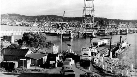
Development of Eurobodalla took longer than might be expected due to three major river systems and a mountainous environment limiting road access. The Clyde River itself had to be crossed twice. A small hand-operated ferry service started in 1891, and expanded through several size iterations over a 60 year period. Also known as ‘the punt’, it served the community well - even hours often spent waiting to cross the river were ‘part of the holiday and lifestyle’.
That way of life changed dramatically with the opening of the first Batemans Bay Bridge in 1956. Then in 1962, the Kings Highway was fully sealed, providing easy weekend access to the Batemans Bay area from Canberra and Queanbeyan.
Finally, in 1964 a bridge over the Clyde at Nelligen replaced its punt service – which, as some recall, meant no more male ‘enforced’ stops at the riverside Steampacket Hotel whilst their womenfolk kept a foot on the car’s brake whilst awaiting their turn to cross the river on the punt.
The Bay’s medical needs were initially met by a bush nurse and a two ward cottage hospital. This was patently inadequate by the 1960s, particularly during peak periods, prompting the local Hospital Appeal Committee to erect a ‘blood dripping’ banner at the highway intersection into town reading ‘Don’t Have a Bloody Crash Here! Very limited hospital facilities.’ This received national media coverage…but it took another 10 years before a new hospital was finally opened in 1970; its status is currently the subject of a review by the region’s health services.
The population of Batemans Bay reflects the periods of the area’s greatest growth - from the 1960s, but particularly from the 1980s. The 1881 census records 266 people (that is, property owners). In 1981 it was 4,924. By 2016 this had grown to 11,290 across the Bateman’s Bay district. During peak holiday periods, however, population numbers explode!
From the 1960s, the Australian public service was increasingly moved from Sydney and Melbourne to Canberra, with Batemans Bay actively promoted as the nearest seaside location to the national capital – so, to many people, it was viewed as being "Canberra by the Sea", a popular destination both for holiday-makers and for retirees.
Floods and fires in and around Batemans Bay have challenged the area throughout the 19th, 20th and 21st centuries – the most recent being the horrendous 2019-20 bushfires in which (as the Eurobodalla Shire Council website glibly records) ‘hundreds of homes, many businesses, and thousands of hectares of bushland were damaged or destroyed.’ In particular, Batehaven and the small township of Mogo, experienced frightening devastation. The popular Eurobodalla Botanic Gardens lost many hectares of forest, but fortunately its Herbarium and some buildings were saved. It has literally risen from the ashes with new facilities and provides a haven of natural beauty and environmental education.
In recent years, Batemans Bay has transformed from a community principally comprising small family and holidays homes to a more-diverse community now including retirement villages, apartment blocks and substantial homes. As an important service centre, the Bay is primarily driven by tourism and the demands of a changing demographic.
Today, Batemans Bay has an extended suburban sprawl both north and south of the river and it is hard to tell where the town - now the largest coastal community between Wollongong and Melbourne – finishes, and some of its satellite communities begin.
For all its working life the Bay’s iconic lifting span bridge was the welcoming ‘face’ for arrivals to the district. Acknowledging an overwhelming increase in traffic, the State government has invested in bridge replacements (the Bay in 2022, and Nelligen in 2023) which have further impact the lifestyle of residents.
Collated by Peter Lacey and Myf Thompson. Sources: Clyde River and Batemans Bay Historical Society Archives; www.aussietowns.com.au; Yuin, and Batemans Bay, Wikipedia.org retrieved 2022; ‘Batemans Bay: Story of a Town’, Allison M. James, Surfside, 2001; ‘A Brief History of Batemans Bay’, G T & M L Reynolds, Clyde River and Batemans Bay Historical Society, c.1988; ‘Peas, beans and riverbanks: seasonal picking and dependence’ John M White, extract from ‘Indigenous Participation in Australian Economies’, ANU; Community Profile, Eurobodalla Shire Council, retrieved 2022.
Photograph: the original Clyde River Bridge, just before it was opened in 1956, with 'the punt' it replaced in the foreground.