South Coast NSW History Story
BEGA
Beginnings
From the early 19th century, squatters and settlers in New South Wales were looking to acquire land outside of the confines of Sydney. If land was to be made available to them, some orderly planning was necessary - if only to enable the boundaries of new rural properties to be defined. This meant that land first needed to be set aside for roads and associated infrastructure, such as travelling stock reserves…and the boundaries of towns needed to be defined.
Teams of surveyors, under the control of the colonial Surveyor General, were despatched to explore and map the land and they, in effect, determined where roads were to be built and towns were to be located.
These surveyors did not always make the best decisions. Bathurst, for example, was originally sited at what is now Kelso (on the other side of the Macquarie River, to the east of Bathurst) and Goulburn was originally sited in an area that is now North Goulburn. Practical considerations resulted in these towns being subsequently moved to and developed on their present sites.
Bega, too, is no longer on its original site – which was on the northern side of the Bega River in the area now known as North Bega. That Bega township was surveyed by Assistant-Surveyor Parkinson in February 1851. On 30th December 1851, the N.S.W. Government Gazette included a notice reading: ‘BEGA. Notice is hereby given that a site has been fixed upon for a township at the undermentioned place; and that a copy of the approved plan has been deposited for information at the Police Office, Eden, and at the Office of the Surveyor-General in Sydney, viz: BEGA on the Bega River in the County of Auckland’.
The site was chosen because it was near what appeared to be two permanent, gently flowing supplies of water and it was central to the few settlers in the vicinity (at Yarranung, over the hill to the north of the current Bega Cheese factory, and at Tarraganda to the east of the present town). Most of the surveyed land rapidly sold, but purchasers were reluctant to build on their land because of the danger of flooding. A raging flood in May 1851, in which 17 people were drowned, and another significant flood in 1857 revealed that much of the surveyed township was prone to be flooded…so the fledgling town was moved to more suitable, higher ground south of the river.
Thankfully, little construction had occurred north of the river – a Captain John Grant (the first man to sail up the Bega River and later the Postmaster at Tantawangalo) observing ‘there was not at that time a house in South Bega; about three in North Bega’ – so the move south was a relatively uncomplicated occurrence.
Bega Township
The new township was surveyed by Assistant Surveyor Drake in February 1854 on land that had been Henry Badgery’s squattage, and the first blocks were offered for sale by auction in August the same year.
It is likely that the most suitable crossing of the Bega River (at the bottom end of what is now Auckland Street) dictated the original layout of the new town and led to the lower end of Auckland Street becoming, in the early years, the main street of Bega. (This Auckland Street crossing was still being used at least up to 1900 by horse- and bullock-teams.)
But, as historian W A Bayley noted ‘For whole winters the river could not be crossed at Bega at the Auckland Street and Tarraganda Crossings. McGregors, in 1867, made a log raft capable of carrying 8 to 10 people across the river.’ The cost: 1 shilling per passenger, 6d for a horse!
So, a bridge from North Bega was constructed in 1878 and was opened by Daniel Gowing, a well-known local farmer and businessman. He described it as consisting ‘of six spans, one of 30 feet, one of 40, one of 45, three of 100 feet each, or a total length of 415 feet. The height from the river to the top of the truss-work is 44 feet, from the river-bed to the deck 35 feet. There are 27,666 cubic feet of timber in the bridge…which is known as a Queen’s Truss Bridge, has the largest span in the colony.’ It was located upstream from the crossing at the end of Auckland Street. It was opened with great ceremony. (A bridge at Tarraganda, downstream from Bega, was erected a few years later, providing a second crossing of the Bega River.)
This original Bega bridge, which had serious access problems at both approaches to it, was replaced after 19 years. The new bridge was built in 1898, further upstream from the original crossing and just downstream from today’s Bega Bridge and was connected with the western end of Bega St. A sharp corner onto or off the bridge presented problems to traffic, so eventually the approach to the bridge was extended down to Carp St (today Poplar Ave). The position of that timber truss bridge is, today, clearly visible. This bridge was superseded by the current Bega Bridge in September 1975.
Today’s town was originally surveyed in 1854. It very much simpler than what is there today: the roads running east to west being (from the north) Bridge St (recently re-named Jacksonia Grove by Council – an unwarranted and unnecessary example of local history vandalism!), Lagoon St, Bega St, Carp St, Upper St and High St; those running north to south (from the east) being East St, Parker St, Gipps St, Auckland St and way over west near the river, Valley St and Angle St. Streets such as Church St and Canning St were later additions.
In general, small blocks for houses and businesses were designated between Auckland St and Parker St south from Lagoon St and down to High St, and running in the other direction between Upper St and High St from Parker St to Angle St. Again, in general, land to the west of Auckland St and east of Parker St were large acreages; the whole of the western frontage to Auckland St between Bega St and Carp St, for example, was two 2 - 3 acre blocks both owned by S. L. Bransby; and from East St to Parker St there were just two blocks of land, each the size of or larger than the current block occupied by the Showground, between each of the streets that ran east to west.
As had happened when North Bega was surveyed, demand for the surveyed town blocks in (south) Bega was exceptionally high. Most blocks had been sold by about 1860; and even Kiss’ Lagoon had been sold by 1875. In a significant number of instances, town lots were brazenly purchased for immediate amalgamation with adjoining agricultural blocks.
The first recorded house in (south) Bega was erected by Ferdinand Beck in Auckland Street, above flood-level and just up from the current primary school grounds. Opposite were several blocks owned by Ann White. Another building opposite the school was occupied by a Mr Diversi, and became the first store in Bega. It was run by a Mr Dawson.
Perhaps unsurprisingly, the first public buildings erected in the new township of Bega were a pub (an inn, that served both liquor and provided lodging to travellers) and churches.
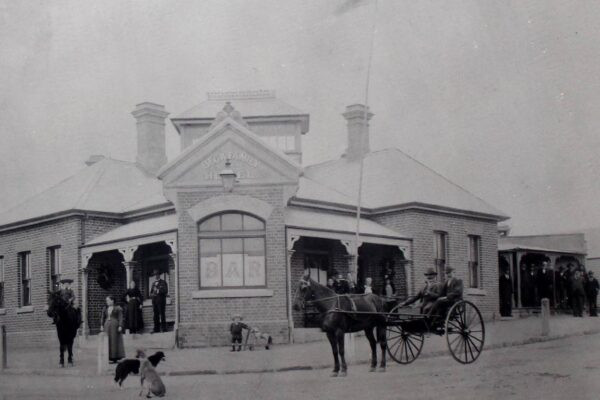
Ann White and her husband had previously operated a ‘shanty inn’ on the banks of the Brogo River at Yarranung, north of Bega, from the early 1850s. They rapidly moved their business to the emerging township Bega, trading under the name of the ‘Victoria Inn’. In 1855 Isaac was killed, so Ann took over the business license and by 1858 had the Victoria Inn constructed of brick in Auckland Street (now No’s 38 and 40 Auckland St). This was probably the first brick building in Bega and, today, the Victoria Inn complex is the oldest surviving building in Bega. The Inn had 3 parlours, 10 bedrooms, a kitchen, stables and coach house, and as noted Bega historian, William Bayley observed, ‘the town grew up around it’. The adjacent Family Hotel (now the Bega Pioneers’ Museum premises) was built in 1859 and is the second oldest surviving building in Bega.
The first mail service to the town (on horseback) commenced in 1856 and, as the township emerged, the first telegraph line was installed in 1869.
In 1857, building commenced on a weatherboard Anglican church on the site of the present St John’s Church Hall in Bega St. It was dubbed ‘Noah’s Ark’. The materials were brought from Sydney and local farmers back-loaded them to Bega on bullock drays after they had delivered their produce to the port in Merimbula.
The church was opened on January 3 1858…but by 1860 there was still no clergyman in town. By 1871 it was reported ‘the Church flaps around like a tent-cover, the whole building quaking and grunting as if about to collapse itself’ so, in 1872, a site for a new church was selected on the corner of Carp and Union Streets. The foundation stone was laid on January 26, 1874. Work on the project failed and the land was sold to a Dr Shiels for £160. (Dr Shiels, several years earlier, had successfully championed the construction of the Bega School of Arts.)
A brick Anglican Church was eventually built in Church Street and was opened in January 1878. The first resident Church of England clergyman in Bega was Rev J. L. Knight, who arrived in the late 1850s. (A brick Church of England School Hall was built on the site of the original weatherboard Church in 1898, the result of fundraising by Mrs Louisa Evershed, the wife of Dr. Montague Evershed.)
It took several more years for commercial activity to commence in the town with the 'Illawarra Mercury' observing on 9th March 1857 that ‘There is a good opportunity for some party with capital to commence storekeeping in our (Bega) town. It would be a safe and remunerative affair and a great accommodation to the district.’ The same article also noted that ‘an Anglican Church is about to be erected’ and ‘brickmakers - steady men – would be sure of profitable employment, as there are many persons anxious to buy bricks.’ William White began brickmaking later that year, his bricks being used in Mrs White’s ‘Victoria Inn’, in Mr Needham’s ‘Family Hotel’, and in other early buildings. The bricks were made from clay dug from near Glebe Lagoon and were wood fired.
From that point, the town grew relatively rapidly and assumed the character of a substantial and permanent town. By 1861 Bega’s population had grown to 625, representing around 100 households. Initially (and, for a long time afterwards…and perhaps it still does!), the town functioned as the social and commercial nucleus for the Far South Coast.
The business and social centre of the town, initially at the lower end of Auckland St, gradually crept around the corner into Bega St (there was a swamp further up Auckland St, between Bega St and Carp St, that hindered immediate development of Auckland St), into Church St. For over 40 years, a vacant allotment behind St John’s Anglican Church served as Bega’s ‘village green’ with facilities for games such as cricket and marbles.
From around 1887 to around 1904, the centre of town moved from Church St into Carp St. This was encouraged by Bega Municipal Council’s desire to create an all-brick, fire-proof town core that satisfied insurance companies and provided lower insurance premiums to landowners. This resulted in the demolition of several, very impressive wooden buildings in Church St. The closures of the large general store operated by H.O.T. Cowdroy (now utilized by Centrelink and Medicare) and loss in a fire in 1910 of Wickham & Co’s ‘Albion Stores’ effectively deprived Church Street of its ‘main street’ status.
The town when surveyed in 1854 was symmetrical, with streets running north-south and east-west. This enabled an orderly residential area to develop immediately the east of the town. The topography of the five or six granite spurs immediately to the south of the town (the northernmost part of Black Range) determined that roads later built in that area would necessarily often be less symmetrical – the main road south from town, Newtown Road, providing the most obvious example. Those with money and those ‘successful’ families, perhaps predictably, chose to live on these elevated granite spurs, above the ‘miasma’ of the valley below, and with their homes having expansive views across the Bega Valley.
The oldest residential area of the town is to the north east (broadly between Bega Street and Upper St, to the east of Gipps St). The ‘suburbs’ of Newtown (south of the CBD) and Fairview (to the south-west of the CBD) were developed later, and generally post-1945. Street names in Newtown (such as McKee Drive, Blomfield Ave, Gowing Ave, Spindler St – all celebrating noted residents of the town) reflect this later development.
Regular population censuses provide an indication of the rates at which the Bega town grew:
1861 625
1871 872
1881 1,634 (I.e. the town had more than doubled in size in 20 years)
1891 2,023 (i.e. the town had more than trebled in size in 30 years)
1901 1,960
1911 1,969
1921 2,024
1933 2,344
1947 2,967
1954 3,644
1961 3,858
2002 4,463 (The Shire’s population was 29,423)
These figures indicate there was initial growth to around 1890 (although in the 1880s Bega was growing at about one-tenth the rate of surrounding villages and half that of Moruya), then there was a period of decline or stagnation to around 1911 (at which time Bega began growing, and surrounding rural towns were in decline), then growth again following World War II.
The Municipality was incorporated in 1883 (Incorporation enabled a Council to be established, thereby giving locals the power under State law to pass local ordinances and enforce them), largely through the efforts of David Kiss (Bega’s Pound Keeper, and a cattle and property dealer, who lived above what is now Kiss’ Lagoon). It was three square miles, and had 25 miles of roadways. (Up until about 1864 there was not a made road in the surrounding district (people travelled along bridle paths; the Princes Hwy did not become a gazetted highway until 1925, at which point responsibility of maintaining it was transferred from local Councils to the NSW Department of Main Roads), although there were formed streets in the town. Around 1864 the Government constructed a road from Moruya to Bega. Daniel Gowing had previously, in 1857, cut a privately financed road from Bega to Tathra. By 1927 it had become possible to travel from Bega to Sydney in daylight; Bega to Cooma took 2½ hours).
By 1873, the main road through town from Tathra to the crossing of the Bega River had been determined: from the Tathra Road one turned left into Upper St, right into Parker St, left into Carp St and right into Auckland St (and, later, left into Bega Street which led to the bridge). This, of course, significantly influenced the way that the town developed.
Macadamisation was carried out and kerbing and guttering was laid. The surviving original stone kerb and guttering (where it has not subsequently been replaced by concrete kerb and guttering) that runs along this route is evidence of this main through-town route.
Local newspapers regularly documented the development of the town:
Bega Gazette, 3.10.1868: ‘Our little township, notwithstanding the dullness of trade, is, though slowly, yet surely, progressing. Within the last 12 months buildings have sprung up, and population increased to an extent little dreamt of a few years ago. Although many of the structures are not of a permanent description (weatherboard), yet they are well-built and ornamental to the town, adding largely to its picturesque appearance. However, there are a few substantial brick buildings erected or in course of erection. The Commercial (or billiards) room, the property of Mrs. Ann White, is a neat, commodious, though plain brick building, is quite finished and adds to the business appearance of Church Street. The Wesleyan Chapel, nearly finished, only requiring the internal fittings, is a tasteful structure, and the only brick building of worship in Bega. Mrs. Prescott’s store, in course of erection, is also a brick building, and will give quite a city appearance to that part of the township. Mr. Malcolm’s store and Mr. W Rixon’s cottage, are two well-built houses; the former is intended for a store; it has a fine imposing shop-front and balcony over it. The latter is a neat weatherboard cottage upon a stone foundation. Mr W. Thomson has erected a weatherboard shop adjoining his store; it is to be occupied by a saddlery establishment. There are several other buildings about to be commenced, among which we may mention the School of Arts, a large store opposite, and dwelling house for the Church of England School. Bega at present presents rather a bustling appearance and however bad the times may be for shopkeepers and farmers, tradesmen cannot complain.’
Bega Gazette, 31.12.1868: ‘Starting at Auckland Street, we notice the erection of extra rooms at the Public School, a new store for Mr. Ellis, and additions to the ‘Gazette’ Office; round the corner into Bega Street, a large butcher’s shop for Mr. Underhill; in Church Street we find a substantial brick cottage, at present occupied as billiards-room and Oddfellows Hall; additional rooms to Messrs. Anderson’s and Sattler’s, and houses and stores upon Mr. Berne’s (a stock and station agent) premises. Next comes the house and butcher’s shop for Mr. Millar, and on the other side the residence for the teacher of the Church of England School. As we reach Carp Street, we observe a whole nest of buildings completed or in progress: a large frame store and dwelling for Mr. Thomson. Messrs. Myers’ saddler’s shop, the School of Arts, and on the opposite corner of Gipps and Carp Streets a fine place of business for Mrs. Prescott. Turning to the right and ascending Gipps Street, we find Mr. Malcolm’s store, a cottage belonging to Mr. Berne. And over the way two frame cottages, the property of Mr. Gleeson, whilst higher up the hill stands the nearly finished Wesleyan Chapel.’
Bega Gazette, 4.2.1876: ‘There is a considerable centre of work in Carp Street. Mr Thomson’s two-storey store approaches completion, Mr Britten’s brick building is being roofed in and the walls of the new Commercial Bank are being rapidly run up. In Auckland Street, Mr Toose’s premises are finished…Mr Shegog’s cottage is nearly completed. In Upper Gipps Street, Messrs. Sonderman and Young’s two cottages have filled up a gap opposite the Catholic Presbytery, and lower down the new premises erected by Mr Hearne, and Mr Braine’s new store, are nearly finished. In the suburbs we notice Mr Walker’s cottage in Chapel Paddock (upper Gipps St) is finished, and Messrs. Curtis’ and Rawlinson’s residences are nearly ready for the paint brush. Mr Sattler’s new villa on this hill is nearly completed. We hear of several buildings to be erected shortly in Auckland Street, on some of the allotments sold by Messrs. Peden and Clissold this week.’
Bega Gazette, 15.6.1887: ‘The principal public buildings are the Court-house, with goal attached; Post Office; School of Arts; and the Lyceum Hall, capable of seating 800 persons. The Churches are St. John’s (Anglican), St. Patrick’s (Roman Catholic), St. Andrews (Presbyterian), and a Wesleyan Chapel. There are also a convent, three banks, and a number of very handsome stores, hotels and private residences. On the opposite bank of the Bega River is the rising and populous suburb of North Bega, which has not yet been incorporated.’
Nowra Leader, 1927: ‘The town itself is not as progressive as the district warrants; no public water supply, and many of the businesses are very old-fashioned. The School of Arts is an old structure of poor design, with a very small hall…A power-house for the supply of electricity has just been completed.’ (The town water supply system was turned on in 1929, with water being pumped from a well to a reservoir. Cost £34,000. Electricity, as indicated, became available in 1927. The town sewerage scheme became operational in May 1937.)
Historian W A Bayley concluded that by the early 1910s ‘stock sales caused Bega to be recognized as the commercial centre of the district, business houses began to flourish, and the town became the district’s cultural centre.’
Post World War II, the town’s role as the principal ‘service centre’ for the NSW South Coast area was reinforced when the State Government located offices of numerous regional departments and authorities in the town, such as those from the Department of Main Roads, the Department of Education, and the Department of Lands. These were in addition to the town being the site of the region’s major hospital, a high school catering to students to Leaving Certificate (later Higher School Certificate) level that attracted students from as far afield as Batemans Bay, Delegate and Bendoc in Victoria, an office for School Inspectors, a regional depot for the Post Master General’s Department, Commonwealth and commercial broadcasting stations, a major butter and cheese facility that also, in 1962, supplied 26% of Canberra’s daily milk supply, and a local newspaper (the 'Bega District News') that had absorbed rival newspapers in Candelo in 1938 and Cobargo in 1950, and regional stock yards that served the area from Gippsland to Moruya.
The Arrival of Motor Vehicles
The first motor cars owned by locals arrived around 1907. The arrival of motor vehicles had many significant impacts on the town, including:
• Local businesses started retailing petrol and oil. Petrol pumps, offering a variety of brands of petroleum, were initially erected on the curbside. This reduced parking space in streets and service station owners, such as Whalan’s Garage in Carp St, were forced to take measures to ensure that access was available to the pumps. Car service centres subsequently emerged, as did car dealerships;
• Many businesses (such as blacksmiths and saddlers) went out of business or changed trades;
• Posts supporting verandahs on commercial buildings on Carp St were removed after World War II – a move considered ‘progressive’ at the time;
• Provision of parking became a significant town-planning consideration;
• Efficient road transport revolutionized retail distribution, so stores in large service centres such as Bega were able to extend their service to wider localities. This impacted significantly on the viability of smaller retailers in surrounding areas;
• The increasing incidence of road accidents in the commercial area led to a push for the sealing and widening of town roads, for the installation of improved street lighting, and for adjustments to be made to intersections;
• The importance of and the prominent role of the town’s hotels and, to a lesser extent, guest houses changed. From the late 1950s, motels emerged (the Black Dolphin Motel in Merimbula, opened in 1960 and designed by Robin Boyd, being one of the nation’s earliest and perhaps most significant examples) which provided accommodation to travellers on the peripheries of the central business district.
Historic Bega Today
The major changes to Bega town since Bayley wrote his history in 1942 have been:
• an expansion in the population and the 'footprint' of the town, resulting in fewer ‘paddocks’ or vacant land remaining in the town;
• the establishment of a significant-size ‘Industrial Estate’ at North Bega, and the disappearance of major industries (such as a tannery, a saw mill…even, recently, the Bega Hospital) from the town precincts. This is partly the result of the drafting of a Bega Municipal Town Plan that commenced in 1946;
• the opening of a new bridge over the Bega River and subsequent construction of the highway that now by-passes the town (in accord with the Department of Main Roads’ policy to construct by-passes of all towns on major State highways; the route for the road was actually gazetted in 1987 and the land for the by-pass was purchased. However, Roy Howard, the Bega Mayor and a prominent businessman in town (he owned Howards Electrical and Howards Hardware), was concerned about the impact a by-pass might have on businesses in Bega, and convinced the DMR to not proceed with the by-pass but, instead, to construct the causeway across Kiss’ Lagoon. The lagoon was very picturesque and Council had been attempting to secure land around it for a park, so dividing it into two smaller lakes created significant angst in the town. The originally-planned by-pass was eventually built and was opened in September 2014);
• a significant realignment of the major road into the town from the Princes Highway (the original town entrance was along what is now Poplar Ave. Once the ‘Kirkland Estate’ became available and the causeway was constructed across Kiss’ Lagoon, this became the main entrance road to the town);
• the construction of a significant shopping plaza (Bega Village - which originally was Sapphire Marketplace - which includes a significant number of car parking spaces) away from the main town street – reflecting a trend in recent decades that has been common in many Australian towns.
• an increase in the rental costs of shops and offices in the main business district from the late 1970s resulted in the ‘creep’ of some businesses (primarily ‘professional’ businesses) away from the main business area into what were traditionally residential streets. This is particularly evident in Canning St (which is now almost entirely a business street) and in Parker St, where cheaper rents and readily-available parking for clients could be found.
Less significant/more subtle changes have occurred – for example recessed entry doors to shops and post-supported verandahs in the town have largely disappeared; the type and mix of retailers has significantly changed (there are now no saddlers along the main street, and kerbside petrol pumps have disappeared).
Six particularly historically-interesting street precincts have survived:
Auckland Street, north of Bega Street: the original Bega CBD and the original roadway into the town. The most historically important nearby sites are the crossing of the Bega River, Nos 38 & 40 Auckland St (Ann White’s Victoria Inn), the Family Hotel building on the corner of Auckland and Bega Sts, the Bega Primary School complex and the Commercial Bank of Sydney building at No 19 Auckland St.
Church St: An area with a notable collection of private and institutional buildings from the Victorian era in what was once the main commercial street in the town. This street (along with its Ayres Walkway ‘extension’) unites the town centre with its broader surroundings: it provides a visual link from the civic precinct, adjacent to Lyttleton Gardens, to Mumbulla Mountain (this has been described as ‘a strong vista important to the character of the town’). Highlights include St John’s Anglican Church, Bell Tower, Church Hall and Lych Gate complex; McNamara’s Centennial Building (Nos 49 – 61 Church St); the Bank Hotel (42 Church St); and the Red Cross Society building (No 33 Church St).
The Commercial Hotel/Bega Court House area: a group of mostly brick buildings built in the inter-war period or earlier, extending from 163-165 Carp St (once Rosevear’s Jewellers) to the Commercial Hotel, plus the other 3 buildings on the Carp St/Gipps St intersection, plus the impressive Dr Evershed Memorial Clock Tower.
The Balmain Brothers Bega Ltd/Grand Hotel area: a grouping of principally art-deco style buildings that provide a unique streetscape in Bega – extending from the old Lyceum Hall building (No 247 Carp St) to around the corner to No 95 - 101 Auckland St, plus the Grand Hotel building.
The Canning Street cottages area: A group of simple cottages, mostly constructed of weatherboard and iron, that demonstrate housing patterns of the early twentieth century. A well-designed Kings Cinema façade in Carp St once terminated (and dominated) the Canning St vista.
The Carp Street (West) streetscape: broadly the buildings in Carp St between Auckland St and Ayres Walkway/Church St.
At least 100 buildings or sites in Bega have historic or heritage significance, so Bega has plenty of interest to those wishing to learn more about the development of the town. Regrettably – and to the great shame of Bega Valley Shire Council who consistently thwarts community initiatives to erect historic signage in the town - there is currently no explanatory signage in Bega highlighting the historical significance of any of the town’s streets and buildings.
Photograph: Bega's 'Family Hotel', the second oldest surviving building in Bega - now occupied by the Bega Pioneers' Museum.