South Coast NSW History Story
NELLIGEN
The little town of Nelligen (pronounced with a hard ‘g’) has an interesting history and like many South Coast townships, Nelligen has had several ‘lives’.
The area around Nellican Creek (the creek that the Kings Highway follows for a short way west of Nelligen) had been surveyed in 1827 by Surveyors Thomas Florance and Robert Hoddle who were mapping an area from Jervis Bay to ‘Mherroyah’ (Moruya) and from Braidwood to Araluen. In late 1829, when Hoddle returned to the area, a 640-acre portion of ‘good forest land at Nellican Creek’ was surveyed for Francis Moylan, an absentee landowner who never visited the area.
Because of its accessibility to the Clyde River, and therefore shipping services, the surrounding area initially attracted the attention of timber-getters.
The town/port emerged on its present site because it was, for all practical purposes, as far up the Clyde River as ships could easily navigate (steamships were working the upstream areas of the Clyde River from as early as 1853) …AND, in 1853 the junction of Nellican Creek and the Clyde River was chosen as the site of the workmen’s camp for those who were constructing the road up the mountains to Braidwood (these were mostly convicts who worked on the section of the road up to ‘Government Bend’, which today is prominently signposted; the remainder of the road to Braidwood was built by contractors)…AND it was likely to become the final destination of the road down Clyde Mountain…AND fresh water was available locally from springs (the Clyde River at this point is tidal and its water is therefore unsuitable for domestic purposes).
As early as 1835 the Colonial Secretary had been petitioned to build ‘a road from Braidwood to Bateman Bay, whereby the Braidwood district settlers might ship their wool and receive supplies.’ In 1852, a second petition, from 26 landholders and ‘citizens of Braidwood’, was also sent to the Colonial Secretary asking that the road be built. This approach seemed to have a positive impact and the Clyde Mountain Road was opened in 1856.
In the early 1850s gold was discovered at Araluen, Majors Creek, Captains Flat, Currowan Creek and Braidwood. So, Nelligen emerged as a major stopping-off point and supply depot for thousands of miners heading to these goldfields
The town was officially gazetted in 1854. Nelligen then became ‘a stirring little township of bark huts, serviced by two large stores of S Richardson (from Braidwood) and Wilson and Bush, from which 18 or 20 teams left daily to convey goods, brought twice weekly by steamers from Sydney, for Braidwood and its goldfields.’
From that point the town grew rapidly. A post office was opened in 1858, a Commercial Hotel was built in 1859, a police lock-up was built in 1860 and Courts of Petty Sessions were held in the town from the next year. The town’s first school was opened in 1865.
A “Nelligen, Clyde River” report in the 'Sydney Morning Herald' in October 1860 includes some interesting observations about the developing town and its surrounding areas:
'This place is assuming a degree of importance for the time, second to no other district in the colony. It is only about three years ago since the dingo, the opossum, and kangaroo could roam undisturbed by the presence of the white man, but they have had to retire to scenes more remote and congenial to their predatory and solitary habits. The gum trees, whose gigantic proportions were enough to frighten modest labour, have also been levelled to the ground, and on their sites are established one large warehouse, belonging to the Illawarra Steampacket Company, (hence the name of Nelligen’s Steampacket Hotel, which opened around 1865) whose steamers visit here twice a week; also, four public houses, two stores, two blacksmith's shops, one baker, and all doing a roaring trade. There are upwards of five hundred horses, and nearly as many bullocks kept continually carrying upon the road, between this and Braidwood and neighbouring gold fields.
The road, like all the other roads in the colony, is in a most deplorable condition, although there are from six to eight horses attached to each dray, it takes from three to four days to arrive in Braidwood the distance being only thirty-one miles. Anyone, to look at the road just now, would be puzzled to think how it was possible for teams to reach their destination. My own opinion is that the road will never be of any really practical use till a tramway is made, which could be done for about four thousand pounds a mile. Taking into consideration the immense traffic, I am of the opinion that, if a private company could be formed for its construction, the returns would be ample.
We are expecting an extensive land sale here on the fifth November, which it is hoped will be the
means of increasing our population. The land is of an excellent quality for agriculture purposes with never failing streams of water. The Major’s Creek and Araluen gold fields are doing well as usual, but Mogo at present is rather easier. I might say to the unemployed, that a tailor, a shoemaker, and a wheel wright might get plenty of employment in this part.'
By 1892 the town had a population of over 500. (By 1934 this had fallen to 350, and by 2006 - with the opening of bridges over the Clyde River at Nelligen and Batemans Bay effectively depriving the township of much of its trade from passing motorists - this had further declined to 228.)
Unsurprisingly, one of the early buildings in the town was an inn - Richardson’s Inn (it opened c1850), sited just up the road from where the River Café (it being the site of Shoebridge’s General Store and, from around 1900 to 1939, O’Connor’s General Store) operates today. As noted above, by 1860 the town was supporting four hotels, but in 1866 just one hotel remained in town - the Steampacket.
The Steampacket Hotel was originally sited where the River Café is today. It was a single-storey building. In 1898 it, along with other buildings along the river, were impacted by a major flood. The 'Moruya Examiner' reported on 4th March 1898 that ‘at 3 o’clock the flood was in every room of the hotel, and Mr Thompson had to remove his wife and family to higher and drier ground. At 10 o’clock that night there was over 5 feet of water in the hotel bar.’
So, in 1900, the hotel was demolished and a new two-storey Steampacket Hotel was erected on the same site – but at a level four feet higher than its predecessor. It burnt down in June 1925, so its owners moved the business just down the street to an abandoned cheese factory and, about five years later, extended the building.
That Steampacket Hotel operated until 1967. But by that time, the opening of a new bridge (see below) had diverted passing traffic away from the centre of Nelligen, so the licence and hotel’s name were transferred to a new site on the highway to the west of town. The new hotel was to receive an architectural award for a modern building blending into its local environment.
Opposite the original Steampacket Hotel, adjacent to the river, the Illawarra Steam Navigation Company had its massive warehouse (it was 40 metres long and 15 metres wide) and jetty. These operated from around 1858 to 1951 with the company running a twice-weekly service to the port for most of this time. Milled timber, railway sleepers, wattle bark, dairy products, pigs and poultry, farm produce, oysters, wooden wheel components, and, for a period, gold, were the main goods shipped out of the port.
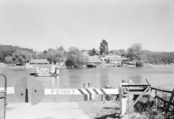
Slightly further downstream was a ramp for the mechanical vehicular ferry across the Clyde River that operated from 1895 to 1964. This replaced a private hand-operated ferry that had operated from 1875.
The Ferry Master’s cottage was on the opposite side of the river – which proved to be quite a convenient location for the hotel’s patrons who were still drinking after the hotel had legally closed for the night, because any police ‘raid’ would be delayed by the ferry master until the drinkers had enough time to disappear into the night. (Prior to the ferry being installed, the main road from the north joined the road down the Clyde Mountain and then followed the river, on the western side of the river, from Nelligen downstream to Runnyford before climbing again to join the current Princes Highway just north of Mogo.)
The Nelligen ferry became very busy in its later years, and often queues of traffic would be banked up waiting to cross the river – giving drivers ample time to quench their thirsts at the Steampacket.
In 1954, 7,500 vehicles crossed the Clyde by ferry at Nelligen. Even then delays of up to 3 hours could be experienced to cross the river. By 1963 this had grown to 30,000 vehicles – so (finally, having taken almost four years to construct!) a new bridge was opened in December 1964. This was replaced with a new bridge in 2023. (As an aside, the number of vehicles using the bridge at Nelligan now exceeds 1.5 million annually.)
An appreciation of the interesting history of this little township – including its ups and downs, and reflected in the remnants of many public buildings so typical of many Australian country towns (Churches, the hotel, a school and teacher’s residence, the post office, the police station and courthouse, a cemetery, a war memorial, a Mechanics Institute, etc.) and a ‘very dead tree trunk known as the 'Bushranger's Tree'. A plaque on the tree explains that this is: "The remains of the 'Bushrangers Tree' where it is maintained the Clarke Brothers were chained awaiting transportation to Sydney and execution on 25th June 1867 for multiple murders. The Clarke gang operated during the 1860s goldrush ambushing shipments from the Araluen and Nerrigundah fields, until cornered by troopers led by Aboriginal trackers in the Jingerra Ranges during November 1866"’ - can be readily gained from the numerous interpretive information panels scattered throughout the town.
Sources: www.aussietowns.com.au/town/nelligen-nsw; Nelligen Main Street Study at http://www.esc.nsw.gov.au/living-in/about/culture-and-heritage/heritage/Nelligen_Main_Street_Study.pdf; Wikipedia; Eurobodalla Tourism’s ‘South Coast Travel Guide’ at southcoasttravelguide.com.au; The History of the Port of Nelligen by G T Reynolds.
Photograph: The Ferry at Nelligen