South Coast NSW History Story
NOWRA
Early Exploration
The first Europeans to traverse the South Coast were survivors from the ‘Sydney Cove’ shipwreck in 1797. Their reports prompted George Bass to sail down the coast later that year. He followed Seven Mile Beach south, crossing the shoals at the entrance to the Crookhaven River. He was unimpressed with the shallowness of the river mouth, so named the area 'Shoals Haven'.
In April 1805 the coastline was mapped by surveyor James Meehan. On this expedition he came close to losing his life when his boat was caught in a gale and was almost driven ashore at Shoalhaven Heads. He succeeded, however, in travelling upstream along the Shoals Haven River to its tidal limit (Burrier) and up Broughton Creek to its limit of navigation, noting large stands of cedar in the area. This soon attracted cedar-getters to the area. They would float their logs down the river to Greenwell Point where they could be loaded aboard ships and taken to Sydney.
The cutting of cedar became so prolific that, in December 1814, the government prohibited the cutting and removal of timber from the Shoals Haven, ostensively because of ‘considerable abuse’ of permits that had previously been issued. The prohibition, however, was short lived.
In 1812 surveyor George William Evans, guided by an Aboriginal man named Bundle, journeyed from Jervis Bay to the Shoalhaven River. They crossed it in a bark canoe about 1½ miles west of present-day Nowra and climbed Cambewarra Mountain, before descending to Broughton Creek.
In 1818, James Meehan returned with explorers Charles Throsby and Hamilton Hume. The men had been tasked by Governor Macquarie to find a route from the Southern Tablelands to Jervis Bay. Charles Throsby is credited with then having recorded the local Aboriginal name for the area – ‘Nou-woo-ro’, meaning ‘black cockatoo’. This subsequently was adapted to become the name of the local town, Nowra.
Settlement
From 1822, Alexander Berry was granted significant swathes of land along both sides of the Shoalhaven River. One portion he did not secure was 1,300 acres on the south side of the river that was promised by Governor Brisbane in 1824 to Jean Charles Prosper de Mestre (a French-American-Australian who became a prominent businessman in Sydney from 1818), although for some reason de Mestre did not receive the title deeds until 1836.
(Later, Prosper de Mestre’s son, Etienne de Mestre was the trainer of Archer, the horse that won the first and second Melbourne Cups. Legend has it that de Mestre and Dave Power, a stable foreman, walked and rode Archer the 550 miles from Terrara to Melbourne to enter the first running of the Cup, but two newspaper articles suggest otherwise: ‘Bell's Life in Sydney and Sporting Chronicle’ reported on 21st September 1861 ‘Wednesday last saw the departure of Mr De Mestre's three nags for Melbourne, and by this time we trust they have arrived in good order. A large number of friends went down to the wharf to see the horses on board, and we may safely say that wishes for the successful issue of the trip are very general.’ Two weeks later ‘Bell's Life in Victoria and Sporting Chronicle’ announced: The ‘City of Sydney’, which reached Sandridge (Port Melbourne) on Saturday last brought the Sydney entries for the Melbourne Cup, viz, Archer, Inheritor and Exeter. Archer is considered the best old good 'un in New South Wales. The horses reached this colony without a scratch.’ Etienne de Mestre also trained Tim Whiffler that won the 1867 Melbourne Cup, Chester that won the 1877 Cup, and Calamia that won the 1878 Cup.)
Prosper de Mestre named his land grant ‘Terar’. He had the area surveyed in about 1839, and a sizeable village, named ‘Terrara’ (its name was changed to Terara in 1935), developed there.
Three wharves were constructed in 1854, and a steam-driven flour mill was erected in 1856. A ferry service across the river commenced in 1866, a local newspaper was established in 1867 and by 1870 the town had nine hotels, four general stores, a town hall, a post office, a butcher's, two banks, and numerous other establishments.
About 3 kilometres west of Terrara is present-day Nowra. It had been surveyed by Thomas Mann in 1852 and the ‘Village of Nowra’ had been defined. Several allotments were sold in 1856 and settlers started to build in what was then described as ‘a waste of gum trees, the domain of the wallaby and the dingo.’
Two Floods…the Centre of Settlement Moves
In 1870, there were two major floods on the Shoalhaven River, one in March, the second in April. This is how the ‘Sydney Morning Herald’ reported the second: ‘Terrara, 29th April 1870: The heaviest flood ever known here has fallen on us, causing an immense destruction of property. The stores of Mr Holmes are destroyed. The steamers’ store, in front of Mr Armstrong’s premises, and the Telegraph Offices are washed away. Goulding’s farm is destroyed, not a vestige of the house and barn remain. Large numbers of cattle are lost; immense distress will prevail; and, saddest of all, five lives are lost.’
The Illawarra Steam Navigation Company’s vessel, the ‘Coolangatta’ that transported goods along the river to and from Greenwell Point, was swept 80 metres inland by the flood. It took many weeks to haul it back to the river…only for it to be swept away by another flood in 1873, on that occasion becoming a total wreck!
Those 1870 floods basically resulted in Terrara being abandoned in preference for settlement at the ‘Village of Nowra’, which was located on higher ground. And, then, Nowra’s position as the area’s principal town was reinforced:
• Initially, by Nowra township site having been gazetted in 1852 after it was surveyed by Thomas Mann. (The municipality was incorporated in 1871.)
• Then, in 1866, by the establishment of a public ferry that linked the east side of Bomaderry Creek (on the north side of the river) to Ferry Lane (on the south side of the river) – a service that was (even though a more expensive service) more convenient than the service established by Alexander Berry that connected the eastern side of Broughton Creek (on the northern side of the river) to Numbaa (on the southern side of the river, downstream from Terrara). (That ferry crossing, of course, made total sense to Berry’s interests, because his focus was on developing the township of Broughton Creek, later to be renamed Berry!)
• Then with the opening of the Nowra road bridge in 1881. This is a structurally-interesting wrought iron ‘Whipple Truss’ bridge that was prefabricated in America. At its opening it was suggested ‘it is intended to be used at present for ordinary traffic, but may ultimately be appropriated for the purposes of railway traffic also’, although its narrow 20-foot wide carriageway made this impossible.
• Between 1881 and 1891 the population of Nowra virtually doubled to 1,705.
• Then, in 1893, with the completion of the railway link between Kiama and Bomaderry. (The government surveyed a route and allocated Crown land to extend the railway as far as Jervis Bay. Somewhat optimistically (and mirroring what was later to occur in Wolumla), a street in Nowra was named Station Street in anticipation of this railway extension.)
By that time, Nowra was exhibiting all the signs of permanency: in 1861 a post office service was commenced (the post office building being erected in 1883); it had a newspaper, the ‘Shoalhaven Telegraph’, which was published from 1879; the present courthouse was opened in 1897; the Nowra police station in 1900 (converted to a museum in 1980); the first factory of the Nowra Co-operative Dairy Company opened in 1902; gas lights were installed in the town in 1902; coal gas became available in Nowra in 1905; electricity was introduced in 1927 (after Bomaderry!).
A rock barrier on the Shoalhaven River initially prevented ships from sailing right up to Nowra. This was blasted away in 1904, thereby making the town more accessible.
During World War I, one of the ten ‘snowball’ recruiting marches that took place in NSW started in Nowra. It departed from Nowra on November 30th 1915 and basically headed up the coast, ending on 17th December 1915 at the Domain in Sydney. The marchers became known as the Waratahs, and around 120 volunteers were recruited from the march.
During World War II Nowra became a military town with up to 1,500 personnel stationed at RAAF Nowra (now HMAS Albatross; the facility was transferred by the RAAF to the Royal Australian Navy in August 1947) from July 1941, and with ships and submarines from the British Pacific Fleet passing through Jervis Bay in 1945. RAAF Nowra provided torpedo attack training to Allied forces in the South Pacific, utilising a torpedo dropping range in Jervis Bay and a bombing range on the Beecroft Peninsula (the northern peninsula to Jervis Bay). A Base Torpedo Unit (hence BTU Road) was also established at RAAF Nowra where torpedos were serviced and maintained.
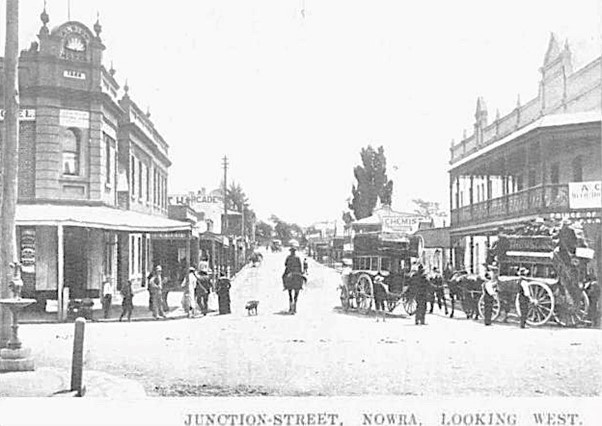
In the 1960s and 1970s the central business district in Nowra changed dramatically, with the demolition of many of the older-style wooden buildings.
In 1980 a new road bridge (which now carries southbound traffic) was built across the Shoalhaven River and in 1983 the main road south was re-routed to by-pass the centre of the town. A second road bridge (now carrying northbound traffic) was opened in February 2023.
When Should Shops be Open?
By the late 19th/early 20th century, shops in NSW rural areas generally opened six days a week, with trading continuing up to 10pm on Saturdays.
In November 1882 a Half-Holiday Association was formed in Nowra to set aside one afternoon each week as a half-holiday. Wednesday was chosen for this, with shops then closing at 1pm.
From 1888 to around 1913 cricket matches were organised on half-holiday afternoons, with matches between, for example, business people v mechanics, those from the north side of Junction Street v those from the south of the recreation ground, marrieds v singles.
In December 1899, a NSW Early Closing Act was introduced that limited trading hours to 6pm on Mondays, Tuesdays, Thursdays and Saturdays, and until 9pm on Fridays. Wednesdays became statutory half-holidays.
In 1913 a poll was held in Nowra to determine whether Wednesday afternoons or Saturday afternoons should be the half holidays. Decisively, the locals opted for Wednesday afternoons to be half holidays.
Another poll was held in 1918. On this occasion the locals voted in favour of Saturday afternoons becoming the half-holiday. A further poll in 1932 resulted in a large majority opting to retain Saturday afternoons as the local half-holiday.